Thursday, September 1, 2011

June 1 - David arrives in Lima and goes directly to Arequipa


David flew into Lima from Seattle and, changing planes, flew directly to Arequipa. He spent the day visiting the Monasterio de Santa Catalina and the Museo Santury where there is a very interesting exhibit of "Juanita the Ice Princess", a frozen body of a young girl sacrificed to the gods by the Incas and left buried on the mountain Nevado Ampato. Apparently she was killed to appease the gods after a major earthquake.  David then spent the rest of the day, unsupervised, taking photos a lo loco.
By the way, Sunday is presidential election day with Keiko Fujimori going up against  Ollanta Humala.

June 2 - David in Arequipa and John in Lima


John flew in from Cordoba, Argentina and was picked up at the airport by a taxi sent from the Hotel Bayview in Miraflores.
Dispite the name, there is no bayview. Maybe there was years ago before the Marriott was built in front of it blocking the bayview.
The area is nice and the hotel is adequate with very helpful staff.
I had lunch at Dama Juana in the Larcomar complex nearby. This restautant has a spectacular view of the Pacific and rocky beach 500 feet below. The restaurant specialized in very tasty Peruvian food.

I spent the afternoon trying to find a way to go to Barranca, a coastal city 200km. north of Lima and the jumping off place for the Caral ruins. No one, not even Google, could give me a straight answer as to whether or not busses serve that Barranca.

I had dinner at Danica in San Isidro, an Itialian  restaurant owned by the niece of a friend and had an excellent risotto with shrimp.

June 3 - Lima to Barranca

While I searched for a bus, I also lined up a taxi to take me to the airport, pick up David and continue on to Barraca. The first quote for the trip was US$250 but eventually I got a driver to argee to US$175.
On the way to the airport, we passed by the bus station of Paramonga Busses located in a pretty rough area. The busses which leave every 15 minutes for the north cost 15 soles to Barranca. So there it was, 30 soles (US$12) for the both of us on the busor US$175 in the taxi. The bus, by the way, had a number of stops on the way and took 5/6 hours.
David agreed, when we met him at the airport, that the taxi was the way to go so off we went into the falling darkness.
Before it was completely dark, we passed through miles and miles of "pueblo jovenes" (young towns) of pretty primative housing built of the sand dunes and rocky barren land. These towns were interspersed with huge chicken house presumably giving work to the occupants of the pueblos.
In Barranca, we checked into the Hotel Chavin and had a good meal in the hotel restaurant.

June 4 - Caral and Forteleza ruins


We took a taxi out to the Caral ruins, about 25 km. from Baranca. A decent road carried us inland through miles of sugarcane.
In an effort to take us directly to the ruins and avoid a half mile walk, the taxista made a short cut that would lead us through a very rocky stream. As a precaution, David and I dismounted before our driver tried the stream bed. A passing campesina woman told the driver to gun the engine as he entered the stream. This turned out to be a major mistake as the front wheeled Toyota dug itself deeply into the bed of slippery, round stone river bed.
We saw visions of our Caral expedition disappear before our eyes but fortunately three locals came to our rescue and help push us out so we went back to the long way.

Caral was well worth the effort. Carbon 14 dating gives the site an age of 5000 years, the oldest city in the America. The site itself consists of 7 piramids built around a great plaza. The site is located above the Supe River in an excedingly dry and dusty ridge. Caral is one of 21 similar and contemporary sites built along this and nearby rivers. While they didn´t have metal nor ceramic, the inhabitants developed a highly structured society which seems to have been geneses of most or all of the subsequent Andean cultures.
After visiting Caral, we drove up the coast north to the huge Chimu fort in Paramonga. This was the furthest south that the Chimu expansion.

And on the way back to the hotel, we stopped off at a museum where Simon Bolivar had lived for a few months as he planned his attack on the Spanish in the highlands.

June 5 - Trip from Barranca to Huaraz

Today we took our same taxista from Barranca up the mountain to Hauraz. It was a 4 hour ride and cost us 300 soles (US$120). The alternative was beat up bus. The road had been recently paved and was excellent, so good that we had to constantly remind our driver that there was no need to race.
The day started with the typical coastal overcast and chill. We drove for at least an hour through sugar cane fields owned by the Patavilca Sugar Cooperative. Finally, we came out of the overcast and found ourselves with a verdant and fertile river valley on one side of the road and absolutely stark stone and sand mountains on the other side. For another hour, we traveled through this scenery as the road climbed little by little and the power of our car began to weaken as the altitude took its toll on it´s motor.
The gray stark mountains began to turn green. We began to see little houses high up on the mountainsides on both sides of the road. Along the road, people, especially the women, seemed to be dressed up for election day.
By now, we began to see the highland influence with high clowned hats and flaired out skirts of the women.

Before long we reached 4000 meters and the topography turned to a high intermountain plain (altiplano) with the impressive line of snow capped mountains stretching on to the north.
A lonely monolith along the road.
The above is a photo of chili peppers drying in the sun along the road to Hauraz.

Hauraz came into view shortly. The earth quake of 1970 had pretty much knocked down the city so it had been rebuilt in a faux colonial style. It not too bad but not as charming as a real highland colonial town. The views from town of the snow capped mountains are spectacular.

Hauraz in a hiking and mountain climbing town so it is filled with foreigners from all over looking especially fit.

We had an excelent aji de pollo at the Cafe Andina.

BTW, Ollanta Humala won the presidential elections in a ballotage against Keiko Fujimori. Some worry that he will represent another Chavista toe hold in the Andes. He has promised to be a nationalista without following the Chavista line. Time will tell.

June 6 - Trip from Huaraz to Parque Nacional de Huascaran


The tour operator picked us up at 9:00 AM in a bus for 25 passengers.
We traveled north along the the Santa River over a pretty deteriorated paved road to the town of Carhuaz where we had an stop for icecream. This stop seemed inappropriate this early in the morning but it gave us a chance to enjoy well designed central plaza and gave David time to warm up his camera trigger finger.

On the way into town, we stopped at a stream bed to see our first evidence of the land slide that wiped out the town of Yungay and devastated the area in May 31, 1970. We could see Huascaran, one of the highest peaks in the Peruvian Andes, looming in the distance. A dark scar on its north face indicated from where the huge rock face loosened by the May 1970 earthquake had fallen.
In May 31, 1970, at 3:25PM, a 7.6 strength earthquake shook the area. The town of Yungay trembled for 5 seconds knocking down practically the whole town killing thousands who were in their homes listening to the World Cup matches in Mexico. According to legend, the priest of the colonial church rang the bells to gather the faithful from the destroyed city. As the survivors congregated in the palm shaded plaza infront of the church, the second step of the disaster occurred.
The rock and ice face of Huascaran which had been loosened by the quake shot down the steep slopes at lightening speed in a massive ice, rock mud avalanch. Flying over low hills, it plow through the already devastated city, engulfing the church and its faithful and covering all  with 6 meters of debris as it traveled down to the river Santa.
Between 25, 000 and 32,000 people lost their lives in Yungay and another 10,000 in the surrounding areas. Now, what had been the city is considered "campo santo" and is unbuilt 40 years later. All that remains from the old city is one lonely palm tree sticking up through the debris from the plaza infront of what had been the church. Now, lovely rose gardens cover the area where the city used to be.

This tragedy framed our trip up the mountain to the Parque Nacional Huascaran. On a number of occasions, David requested a photo stop to shoot up at Huascaran and its dark scar as we drove up its flank or down to the course of the avalanch to Yungay. Fortunately, others on the tour participated with David.
Finally we arrive at the park entrance at 4000 meters. We stopped for a cup of coca tea at a primative rest stop which kept us going as we traversed an incredible pass between Huascaran on our right and Huandoy on our left. Thousands of feet of sheer rock faces loomed up on both sides of us blocking out the sun and straining our necks to see the tops.


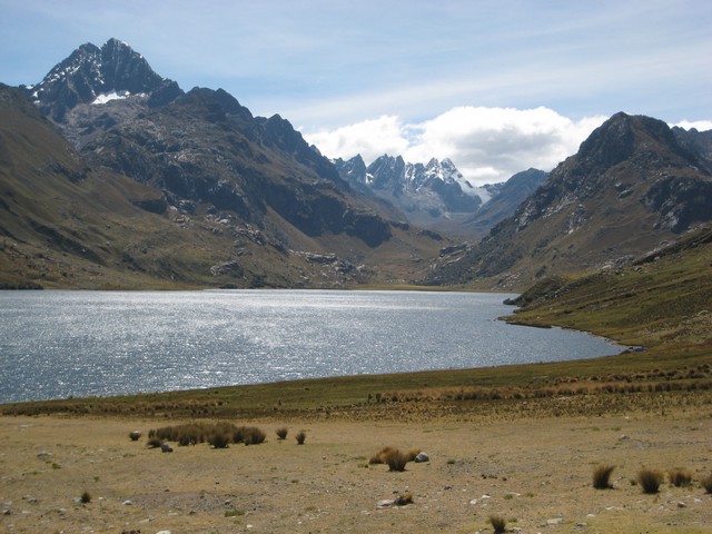
Continuing on, we came to two high mountain lakes, Las Lagunas de Llanganuco. They both were a creamy blue color caused from minerals in suspension and the high altitude light. They were pretty spectacular and well worth the trip. This is an area frequented by trekers during the summer treking season.


Fortifying ourselves with another cup of coca tea and roasted Andean corn, David and I hiked down a trail from the lakes back to the road through pass and a forest of magical trees. This trail seemed almost subtropical due to the micro climate created by the shelter of the rock faces and abundant water from glacial runoff.
By this time, 3:00PM, we were tired and hungry and looked forward to lunch an hour away in Caraz. We had pretty decent trout with spicy sauce.
From there, we returned to Yungay to walk the "campo santo" and see the devastation on the ground.


Finally we rolled into Huaraz, exhausted.

June 7 - Chavin de Huantar

The bus with 14 passengers picked us up today and we were pleased to see that we had the same guide that we had the day before. Nilda is very knowlegible about the area as well as being very simpatica.

The way to Chavin took us north along the excelent road we came in on from Barranca Sunday. At Catac, a small farming community, we turned east toward the Cordillera Blanca. The road was terrible, with huge potholes and patches of deteriorated or deteriorating blacktop.
The view was a feast for the eyes. A high intermountain plateau swept up toward the Cordillera Blanca with a dozen high snow capped peaks stretching off to the north toward Huascaran.


After suffering for an hour and a half on the road, we reached the high point of the trip, the Cahuish Tunnel  (14,816 feet). Passing through it, we left the Pacific watershed and entered the watershed which feeds the Amazon basin. Almost immediately, we noticed ever increasing greenery as we dropped down into the Chavin watershed. Patchwork farms appeared on the hillsides with villages in the valleys.

In about another hour and a half from the tunnel, we rolled into the town of Chavin. David, as well as Elena and I had visited the town and site before, David in 1968 and we in 1977. The town certainly had changed. Most of the houses had a relatively new coat of paint and there were some decent hotels as well as restaurants. In addition, a beautiful new museum financed by the Japanese Embassy had been built.
Neither David nor I could remember much about the Chavin ruins except the tunnel leading to the famous "Lanzon", the stone representation of the Chavin cosmos, which was at the end of a narrow tunnel under part of the piramid complex.

The Chavin culture flourished about 900 BC and served as a theocratic center for the Chavin culture. It appears to have been a pilgrimage center to which people from far and wide came to bring tribute and hear predictions from the priests that could effect planting and harvest seasons. The culture flourished for 900 years and, even after it passed into history, the culture´s influence remained strong in subsequent Peruvian cultures.

The piramids and the stone courtyard are very impressive.


This is the entrance to the biggest piramid.To the left the white stones represent the male side of the duality and the right the female.


In a tunnel under the complex.


Pieces in the new museum.


Others views of the town of Chavin.


Our guide, Nilda, and the Raimundi Stone which details the Chavin world view.

This stone was looted from the site many years ago and was found being used as a table in the house of a local land owner with the bas relief side down. Raimundi, a lunch guest at the home of the land owner, lacking a napkin, wiped his hand on the underside of the "table" and discovered the bas relief. Thus, the world recovered a priceless archeological piece.